

 |
Day 20 | Round Robin One |
      |

|
Date:      Wednesday, August 6, 1997
States:    (UT), WA, OR, ID, UT
Weather:   Clear with very widely scattered
           high clouds
Altitude:  12,000 - 12,500 ft MSL
Dep Time:  7:12am MDT (1312 UTC)
Arr Time:  3:40pm MDT (2040 UTC)
Airtime:   7 hr 1 min
Distance:  919 nm
Avg Speed: 131 kts
Fuel Burn: 88 gal
|
|
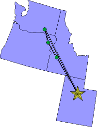
We took an additional day off, waiting for weather improvements, so we got going again on Wednesday. We left Provo (PVU) at 7am and headed out for Walla Walla, Washington (ALW). We decided to take the longest leg first, the catch the other stops on the way back. We filed IFR, and we flew in mostly visual conditions with an occassional penetration through a cloud or layer. We flew at 12,000 feet all the way to Walla Walla and it was good that we went IFR, otherwise we would have done a little bit of cloud dodging in spots. But, we left the clouds behind just north of Boise, Idaho (BOI), and we flew in the clear northward. Just about over Baker, Oregon (BKE) we had two very huge, very greasy bugs smack the windscreen with a loud pop. Ooo, were they gooey! We landed at Walla Walla, expecting more green, but no, it was brown. It just looked like a lot of dry farming to us. The hills were brown and the fields were brown. The airport has a little tower but was on the casual side. We parked and went into the FBO office for fuel. While the lineman was loading the fuel, we noticed several 50 pound bags of Walla Walla onions stacked in the corner and almost bought one, but the 50 pounds is just too much for two of us. We mailed our envelope and away we went. Back tracking now to Baker, Oregon we flew VFR and had a warm climbout. The wind was beginning to come up and it was a bit bumpy, but not bad at all. We didn't take long, though, to get to Baker, only 38 minutes of flying. When we set up for our long straight in approach, and called on unicom, we saw various trucks that were on the runway scatter like cockroaches when you turn on the kitchen light. Anyway, the trucks were out building a road to the new AWOS station. We parked and got fuel. The fellow there was kind enough to clean our windscreen of those fat, gooey bugs, too! Away we went to Boise. The ride was hot and a little bumpy, but no problems, and the clouds had almost completely burned off with the heat of the day. We landed straight in on runway 10L and parked at Boise Air Service. We got the fuel load and mailed our envelope. We checked with FSS for current conditions at Salt Lake City and along our route. The clouds were lifting, and it looked VFR. Away we went with Bill piloting this leg. The ride home to Provo was clear, but very bumpy and Jared got a pretty good headache having not eaten all day. When arriving at Ogden VOR we were given the choice of the east side or the west of Salt Lake Valley. Bill chose the shoreline to Lagoon amusement park and down the east side route. Now we were in completely familiar territory and we had a quick run into Provo. We parked, arranged for fuel, and agreed to start out again at 7am the next morning to pick up the very last states in our adventure: CA, AZ, NV. |
No photos for today |
   |
||
| Copyright © 1998 by Jared Blaser. All rights reserved. |