

 |
Day 4 | Arrgh! |
      |

|
Date:      Monday, July 21, 1997
States:    (MS)
Weather:   low ceilings, and generally
           unsettled weather
Altitude:  1500 - 2500 ft MSL
Dep Time:  9:53am CDT (1453 UTC)
Arr Time:  12:47pm CDT (1747 UTC)
Airtime:   2 hr 7 min
Distance:  189 nm
Avg Speed: 89 kts
Fuel Burn: 26 gal
|
|
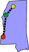
Weather was low, but didn't look too stirred up, and we had the charts that we had gotten in Paris, Texas on Saturday, which covered Mississippi so we had enough to get started. But we could tell that it was going to be an marginal weather day. We needed charts for Alabama and Florida. Our plans originally had been to leave Natchez for Andalusia, Alabama, and then on to Key West, Florida with stops along the way as required. With Hurricane Danny stalled in the Gulf of Mexico, just off shore from Mobile, we were not going that way! So we decided to fly north, and try an end-run around the hurricane toward the east, and then drop down into Florida. This would add hundreds of miles to our trip, but there was no other way. We took off toward Greenwood, Mississippi which was an airport that appeared large enough to have the supplies on hand that we needed. About halfway to Greenwood, ATC advised us that there was a locally heavy rain shower in the vicinity of the airport, so we chose to land at Greenville, Mississippi (GLH) instead. Upon arrival at Greenville, we found three cargo planes from the National Guard flying approaches and touch and goes for practice. I asked Greenville tower for an instrument approach and they responded by sending us well north of the airport to keep us clear of these aircraft, but by the time the tower had sent us 20 miles north, I had had enough of this unproductive maneuvering. I terminated the instrument approach, and made my way back to the airport visually under the cloud deck. Once on the ground we were dismayed to learn that the small FBO there had no charts that would be of use to us. Great, now what? Rather than making another try for Greenwood, we chose to continue north to Jackson, Tennessee, being told that charts would be available there. Why we never thought to go to the other Jackson, Jackson, Mississippi, in the first place I'll never know. It is close to Natchez and big enough that it should have had what we needed. In any case, we were now far enough north that Jackson, Tenn. was the choice, but we didn't have the charts for Tennessee, so we couldn't file IFR. We had to go VFR, and hoped that the weather would hold long enough for us to get there. We launched but as we continued north, the weather started getting lower, beginning to box us in. When we began to loose visual contact with the ground, we knew that we had tempted fate enough and that we had to turn back. We searched our map for the closest airport behind us and landed at Panola County Airport (0M6) in Batesville, Mississippi. Our only piece of good luck all day was from some good people there that invited us to push the plane into their spacious hanger just as the lightning and rain began. In the end we spent the night in Batesville, and enjoyed dinner in the company of our new found friends. This had been a disastrous day that took us nowhere, with frustrations at every turn it seemed. Our original first stop at Greenwood was off limits with heavy rain, the goofy steerings from the tower, and no charts, at Greenville, and our inability of getting into Tennessee due to the degrading weather. We felt like we were dealing with the chicken-and-egg problem. Without charts we couldn't fly in the weather, but the only places we knew to get charts were buried up ahead in the clouds somewhere. Well, we learned our lesson. Get the charts when you can, since you can't predict when you'll need them, or be able to get them. |
|
   |
||
| Copyright © 1998 by Jared Blaser. All rights reserved. |