

 |
Day 5 | The long way to Florida |
      |

|
Date:      Tuesday, July 22, 1997
States:    MS, AL, FL
Weather:   low haze and rain, towering
           cumulus, clear at JAX
Altitude:  12,000 ft MSL
Dep Time:  8:03am CDT (1431 UTC)
Arr Time:  2:12pm EDT (1911 UTC)
Airtime:   4 hr 11 min
Distance:  508 nm
Avg Speed: 121 kts
Fuel Burn: 52 gal
|
|
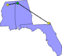
Thanks to our friends in Batesville we had some charts that would get us into Muscle Shoals, Alabama (MSL) where we would be able to get our Alabama landing and get charts for much of the east coast. When we arrived at Muscle Shoals though, we couldn't get any responses from our broadcasts on the unicom so we went ahead and made the approach anyway. Actually, we dropped down toward the airport and we were in the clear so we made a standard pattern to landing. Later, inside the FBO, we learned the our information was out of date. The unicom frequency was really 123.05 not the 122.6 that we had used from our old information. Another lesson learned: have not only the appropriate charts, but also have current airport information on hand. Looking at the weather monitor, we could see that Hurricane Danny had been downgraded to Tropical Storm Danny, yet still had some nasty teeth. Danny was now moving inland, and was just south of Atlanta at this point. Since we were so far north of the gulf coast, it made sense to continue our way ‘over the top' and then turn southward along the South Carolina / Georgia border. This would get us to Florida at last. We filed our flight plan and launched into the sky. Once airborne we went through a layer of clouds and quickly climbed on top. This helped me as I eased into IFR flying for real. Away in the distance to the southeast we could see the huge cloud mass with tops well into the 40,000 foot altitudes. Lots of radio chatter as airplanes were maneuvering to remain clear of the big stuff. ATC asked lots of us how our ride was as we went along. As we came due north of Atlanta, the storm had started hitting the Atlanta area hard. We were glad we were not headed to Atlanta today! Once we passed east of Athens, Georgia we turned south. Our path was more or less direct, but we did zig for a building cloud formation here, and zag for another there, but at least we were headed for Florida. This flight took us in and out of the clouds for half-hour periods at a time. So I was able to get my IFR feet wet without the total commitment of a long distance flight entirely in the clouds. By the time we approached the Florida border, the clouds had dropped to lower altitudes (though we continued at 12,000 MSL) and once over the border, the cloud layer had disappeared entirely, giving us an easy visual approach into Jacksonville (JAX). Once the competent folks at Airkaman had taken care of the airplane for the night, we got a taxi to the Airport Holiday Inn. While down in the lounge relaxing from a tiring day of new experiences, we got to talking with another pilot there that had also come in from Airkaman. Turns out that he, as a corporate pilot, had done a good deal of flying into Mexico, among other places, and he shared a number of horror stories with us about dealing with the authorities in Mexico. Well, after a little more of this talk, we weren't at all sure that we wanted to go to Mexico after all. It was the next morning while riding back to the airport that we agreed to scratch Mexico off the list for this adventure. |
We forgot to take some interesting photos while we faced our first, real IFR day. |
   |
||
| Copyright © 1998 by Jared Blaser. All rights reserved. |