

 |
Day 8 | Twice across the Appalachians, sight unseen! |
      |

|
Date: Friday, July 25, 1997 States: NC, TN, KY, WV, VA Weather: Thick haze up to about 7000' Altitude: 8,000 ft MSL Dep Time: 11:16am EDT (1516 UTC) Arr Time: 5:01pm EDT (2101 UTC) Airtime: 3 hr 11 min Distance: 360 nm Avg Speed: 113 kts Fuel Burn: 40 gal |
|
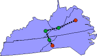
Well, the day progressed, but the clouds didn't burn off. It was another IFR day, though we didn't have any rainstorms. But the haze was thick and there were little cumulus clouds all around. We left Asheville with departure vectoring us to Greeneville, Tennessee (GCY) and the ride was nice enough except for the visibility. We took vectors to the Localizer approach to runway 34 at Greeneville and it was uneventful. We left Greeneville for Ford County, Kentucky (K20) with the clouds were getting taller and thicker. The haze was ever-present. We got into Ford County which has only a VOR approach to runway 14 so we were cleared to the VOR and then we flew the full approach with procedure turn and all. It went alright and we're glad that ‘Otto' was along. We blasted off for Bluefield (BLF) in West Virgina and we flew the VORs rather than using the LORAN. We had no improvement in the weather at all; it was still hazy with fluffy little cumulus clouds that were slowly growing and closing together. We were not able to stay above the clouds on this leg and we flew through a lot! The controller asked if we wanted the full approach at Bluefield, but we asked for vectors which he gladly gave to runway 23 ILS. The landing went well, but we were disappointed with the service at this airport. It was not good, they had no pilot's lounge, nor supplies. Our original plan called for us to go to First Flight, the location at Kitty Hawk where the Wright Brothers successfully flew. But, we departed runway 5 for Charlottesville, Virginia (CHO) after deciding that First Flight was not an option today. FSS had indicated low ceilings and poor visibility so we decided to finish the day in Charlottesville. This leg had us going through some pretty tall cumulus that had built up through the day. Some was okay, some was bumpy. It was something to see those clouds screaming toward you at 160 knots and we had to keep our eyes on the instruments to keep from getting the rushing vertigo that results. Anyway, ‘Otto' helped a lot on this leg. In the end, we pushed out ahead of the tall stuff and had only a layer of low stuff to contend with on arrival, which resulted in a visual approach to runway 3 at Charlottesville. We arranged for a hanger and car and we checked in at the Hampton Inn just south of the airport. We got some dinner and drove over to the University of Virginia campus that Thomas Jefferson built. We walked around a bit and then returned to the hotel. We made a quick stop on the way to the grocery store for some supplies. Tomorrow we'll take in Monticello and if the weather is improved see if First Flight might be a good afternoon flight. We'll keep our fingers crossed. |
We sure provide lousy coverage, don't we? |
   |
||
| Copyright © 1998 by Jared Blaser. All rights reserved. |